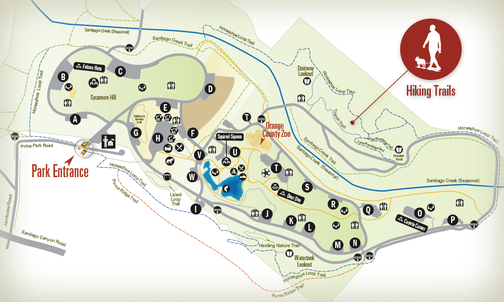
Irvine Regional Park Hiking & Walking Trails
Type: Trails
Status: Open
Length: 1.5 miles
Surface: Sand
Width: 3-12 feet
Rating: Easy
Condition: Good
Roadrunner Loop Trail
This trail begins at the elimination of the Horseshoe Loop Trail in the park’s Villa Park Dam Basin east of the reservoir. The trail follows relatively level terrain as it heads north towards Weir Canyon. The trail borders willow groves, and low land vegetation to its termination and completion of the ‘loop’. This hiking trails proximity to Villa Park Reservoir and willow woodland provides a unique experience and interpretive opportunities.
Type: Trails
Status: Open
Length: 1.5 miles
Surface: Loam
Width: 8-12 feet
Rating: Easy
Condition: Good
Santiago Creek Trail
This hiking trail is used primarily by equestrians from Peacock Hill Stable as well as equestrians accessing Irvine Regional Park from Santiago Oaks Park and Orange Park Acres community.
Type: Trails
Status: Open
Length: 1 mile
Surface: Clay, Rock
Width: 1-2 feet
Rating: Moderate to Difficult
Condition: Poor
Puma Ridge Trail
A single-track trail that parallels the Loop Equestrian Trail, along the top of the parks western ridge. This trail appears to be illegally cut but not maintained. Tread has grown with vegetation in some areas. The trail provides great views in all directions with an intimate view of prime coastal sage scrub habitat. Due to habitat sensitivity and thickness of vegetation, which obstructs user’s sight of vision, the trail should be used by experienced hikers only.
Type: Trails
Status: Open
Length: 4 mile
Surface: Clay
Width: 12 feet
Rating: Moderate
Condition: Good
Lone Pine Ridge Trail
This trail commences at the paved bicycle/walking trail in the park’s natural area on the east of Santiago Creek. Approximately ¾ mile up the east ridge, the trail is joined by a side trail that provides access to the ‘Lone Pine Vista Point’. The lone pine is perched on the top of a popular park eoligi cal feature of sandstone outcroppings. The vista point provides views to the south, east and west.
Type: Trails
Status: Open
Length: 4 mile
Surface: Clay
Width: 2-3 feet
Rating: Easy
Condition: Fair
Toyon Trail
This hiking trail is between the natural area paved bicycle/walking trail and Equestrian (upper ridge) trail. The trail commences at the pine tree grove near restroom #11 and the bicycle/walking trail. It then follows gentle terrain along the sage covered hill crossing a foot bridge and then joining the proposed Lone Pine Ridge Trail.
Type: Trails
Status: Open
Length: 3.25 mile
Surface: Clay, Sand
Width: 3-12 feet
Rating: Easy to Difficult
Condition: Fair
Horseshoe Loop Trail
This trail provides a loop around Irvine Regional Parks Historic Section and panoramic views of the park. A ‘side trail’ provides benches, a shade shelter, drinking fountain, horse trough and hitching post. The views of the park, Santiago Creek and surrounding topography are excellent.


